| |
|
|
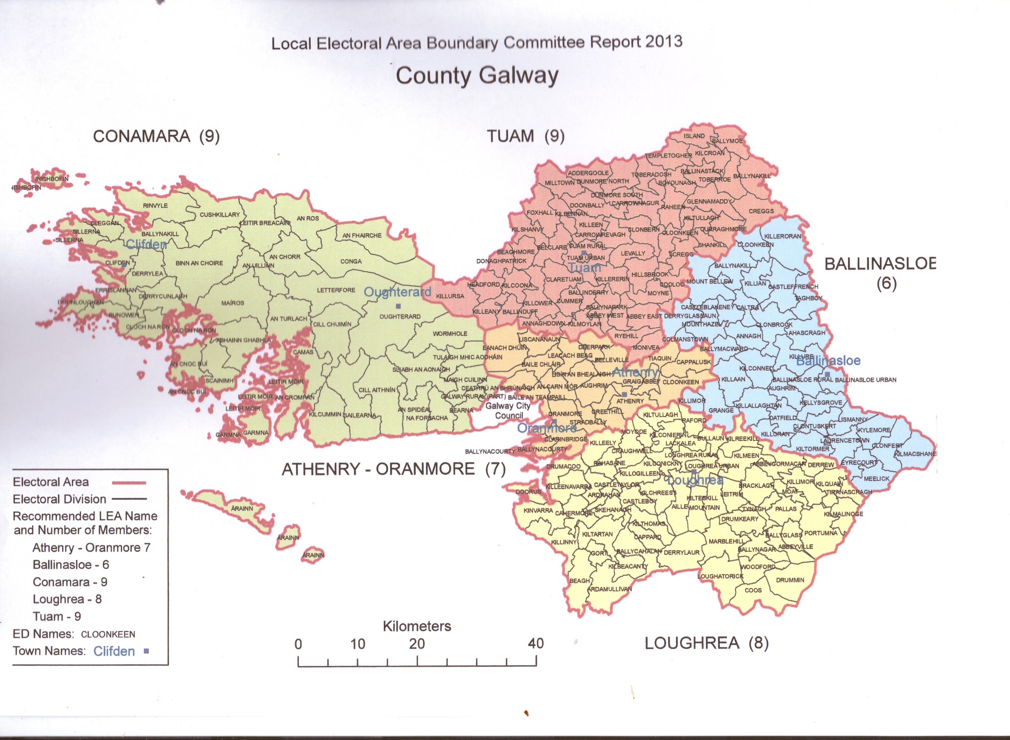
Local Electoral Area Boundary Committee Galway Report 2013 |
| |
|
|
| |
Galway City
Overview of present position
The position at present is as follows:
Local Electoral Areas |
Number of members |
Galway City West |
5 |
Galway City Central |
4 |
Galway City East |
6 |
Total 15 |
15 |
Number of members and population variance
Based on the formula at paragraph 9 of the terms of reference of the Committee the new
number of elected members to be assigned to Galway City Council is set out in the table
below.
2011 Population |
75,529 |
1 member for every 4,830 of the population
75,529 / 4,830 = 15.64 |
16 |
Additional members: 1 per town council, subject to a
maximum of 4 (except in merging councils) |
Not Applicable |
New number of councillors (subject to a minimum of
18 and maximum of 40) |
18 |
Having regard to the requirement that the number of councillors representing a local
electoral area should be not more than 10 or less than 6, the 18 members have to be divided
amongst either 2 or 3 local electoral areas.
Based on the new number of councillors, the population per member in Galway City Council
is 4,196. The terms of reference provide that “within any city or county the variance in
representation of each local electoral area from the average for the city or county should, as
far as practicable, be within a range of +/- 10%”. For Galway City, this represents a range of
3,776 to 4,616.
Recommendations
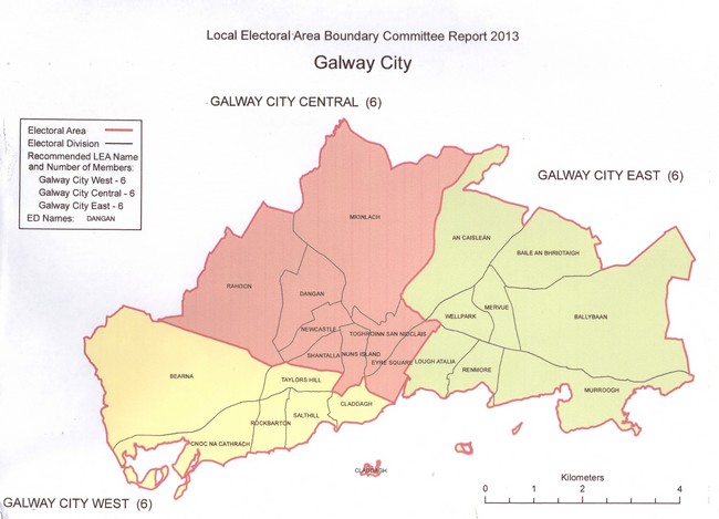
The Committee is recommending that the new local electoral areas be based on the three
current local electoral areas, but with one electoral division (Mionlach) being moved from the
Galway City East to the Galway City Central local electoral area to secure an improved
balance of population across these two areas, having regard to the terms of reference.
The Galway City West local electoral area would remain unchanged from its present
boundaries. There would be no change in the names of the three local electoral areas.
The increase in the number of members from 15 to 18 has enabled this as a recommended
approach to be applied. The parameters set in the terms of reference for the maximum and
minimum number of members per local electoral area and for the preferred representation
variance of + / - 10% between electoral areas are observed.
A summary of recommendations is contained in the table below:
Local Electoral
Areas |
Number of
members |
Population
2011 |
Population per
member |
Percentage
variance from
city average
+ / - % |
Galway City West |
6 |
26,189 |
4,365 |
+4.0 |
Galway City Central |
6 |
23,642 |
3,940 |
-6.1 |
Galway City East |
6 |
25,698 |
4,283 |
+2.1 |
Total |
18 |
75,529 |
|
|
The following is a detailed description setting out the electoral divisions that comprise each
recommended local electoral area:
Galway City West
Bearna, Claddagh, Cnoc na Cathrach, Rockbarton, Salthill and Taylors Hill.
Galway City Central
Dangan, Eyre Square, Mionlach, Newcastle, Nuns Island, Rahoon, Shantalla, and Toghroinn
San Niocláis.
Galway City East
An Caisleán, Baile an Bhriotaigh, Ballybaan, Lough Atalia, Mervue, Murroogh, Renmore and
Wellpark. |
|
| |
|
|
| |
 |
|
| |
|
|
| |
Local Electoral Area Boundary Committee Report 2013
Galway County
The position at present is as follows:
Local Electoral Areas |
Number of members |
Town Council in Local Electoral Area |
Ballinasloe |
5 |
Ballinasloe T.C. |
Conamara |
7 |
|
Loughrea |
7 |
Loughrea T.C. |
Oranmore |
4 |
|
Tuam |
7 |
Tuam T.C. |
Total |
30 |
|
Number of members and population variance
The new number of elected members to be assigned to Galway County Council is set out in the table below.
2011 Population |
175,124 |
1 member for every 4,830 of the population 175,124 / 4,830 = 36.26 |
36 |
Additional members: 1 per town council, subject to a maximum of 4 (except in merging councils) |
3 |
New number of councillors (subject to a minimum of 18 and maximum of 40) |
39 |
Having regard to the requirement that the number of councillors representing a local electoral area should be not more than 10 or less than 6, the 39 members have to be divided amongst 4, 5 or 6 local electoral areas.
Based on the new number of councillors, the population per member in Galway County is 4,490. The terms of reference provide that “within any city or county the variance in representation of each local electoral area from the average for the city or county should, as far as practicable, be within a range of +/- 10%”. For Galway County, this represents a range of 4,041 to 4,939.
Recommendations
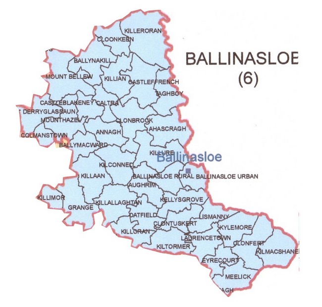
The Committee is recommending a configuration of five local electoral areas, based on the current electoral areas but with a number of alterations that address the requirements of the terms of reference.
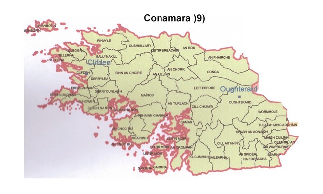
The Committee is recommending that in the interests of electoral, community and geographic coherence, the boundary for the current Conamara local electoral area should remain unchanged and that 9 members be assigned to this local electoral area.
The Committee is recommending a redrawing of the electoral boundaries in the vicinity of Athenry. It is recommended that the town of Athenry and its immediate hinterland be included in same local electoral area as Oranmore. The movement of the electoral divisions of Ryehill and Monivea from the current Ballinasloe local electoral area to new Tuam local electoral area is also recommended.
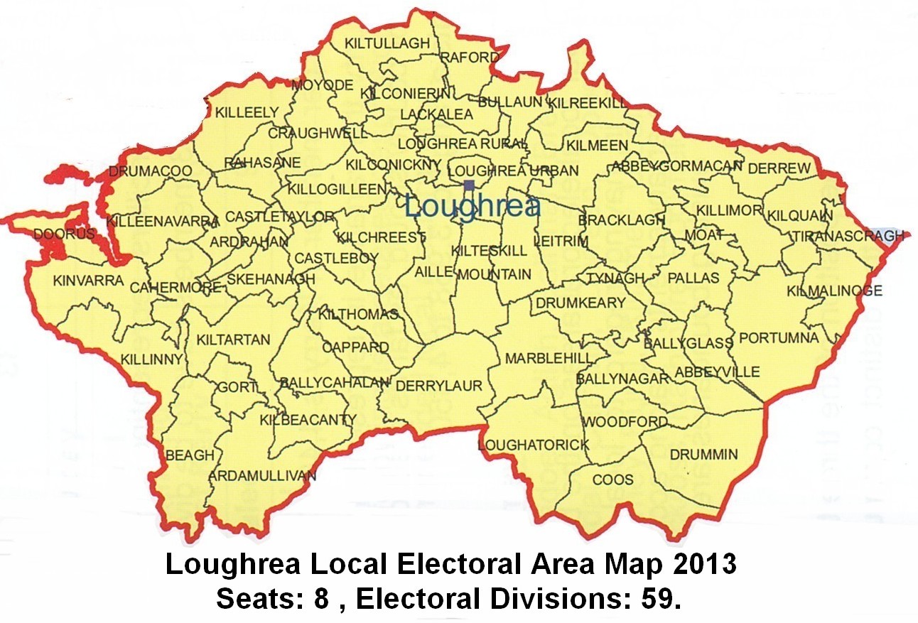
The Committee, having regard to submissions received, is recommending that the electoral divisions of Derrew, Kilquain and Tiranascragh be moved from the current Ballinasloe local electoral area to the new Loughrea local electoral area.
This proposed configuration provides for more coherent boundaries between the new local electoral areas of Ballinasloe, Loughrea, Athenry-Oranmore and Tuam. The Committee is making its recommendations for Galway County based on its terms of reference which provide for local electoral areas to be based around existing town councils and large urban centres, and for account to be taken of the impact on current electoral boundaries and local and community identities.
A summary of recommendations is contained in the table below:
Local Electoral Areas |
Number of members |
Population 2011 |
Population per member |
Percentage variance from county average
+ / - % |
Ballinasloe |
6 |
24,561 |
4,094 |
-8.8 |
Conamara |
9 |
39,238 |
4,360 |
-2.9 |
Loughrea |
8 |
37,416 |
4,677 |
+4.2 |
Athenry -
Oranmore |
7 |
33,415 |
4,774 |
+6.3 |
Tuam |
9 |
40,494 |
4,499 |
+0.2 |
Total |
39 |
175,124 |
|
|
The following is a detailed description setting out the electoral divisions that comprise each recommended local electoral area:
|
|
| |
|
|
| |
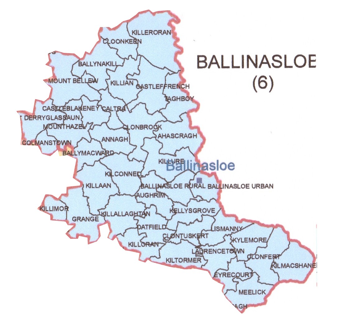
Ballinasloe
Ahascragh, Annagh, Aughrim, Ballinasloe Rural, Ballinasloe Urban, Ballymacward,
Ballynakill, Caltra, Castleblakeney, Castleffrench, Clonbrock, Clonfert, Clontuskert,
Cloonkeen, Colmanstown, Derryglassaun, Eyrecourt, Grange, Kellysgrove, Kilconnell, Killaan, Killallaghtan, Killeroran, Killian, Killimor, Killoran, Killure, Kilmacshane, Kiltormer, Kylemore, Laurencetown, Lismanny, Meelick, Mount Bellew, Mounthazel, Oatfield and Taghboy. |
|
| |
|
|
| |
 |
|
| |
|
|
| |
Conamara
Abhainn Ghabhla, An Chorr, An Cnoc Buí, An Crompán, An Fhairche, An Ros, An Spidéal, An Turlach, An Uillinn, Árainn, Ballynakill, Bearna, Binn an Choire, Bunowen, Camas, Cill Aithnín, Cill Chuimín, Cleggan, Clifden, Cloch na Rón, Conga, Cushkillary, Derrycunlagh, Derrylea, Doonloughan, Errislannan, Galway Rural (part), Garmna, Inishbofin, Kilcummin, Leitir Breacáin, Leitir Móir, Letterfore, Maigh Cuilinn, Maíros, Na Forbacha, Oughterard, Rinvyle, Sailearna, Scainimh, Sillerna, Sliabh an Aonaigh, Tulaigh Mhic Aodháin and Wormhole. |
|
| |
|
|
| |
 |
|
| |
|
|
| |
Loughrea
Abbeygormacan, Abbeyville, Aille, Ardamullivan, Ardrahan, Ballycahalan, Ballyglass, Ballynagar, Beagh, Bracklagh, Bullaun, Cahermore, Cappard, Castleboy, Castletaylor, Coos, Craughwell, Derrew, Derrylaur, Doorus, Drumacoo, Drumkeary, Drummin, Gort, Kilbeacanty, Kilchreest, Kilconickny, Kilconierin, Killeely, Killeenavarra, Killimor, Killinny, Killogilleen, Kilmalinoge, Kilmeen, Kilquain, Kilreekill, Kiltartan, Kilteskill, Kilthomas, Kiltullagh, Kinvarra, Lackalea, Leitrim, Loughatorick, Loughrea Rural, Loughrea Urban, Marblehill, Moat,
Mountain, Moyode, Pallas, Portumna, Raford, Rahasane, Skehanagh, Tiranascragh, Tynagh and Woodford.
|
|
| |
|
|
| |
 |
|
| |
|
|
| |
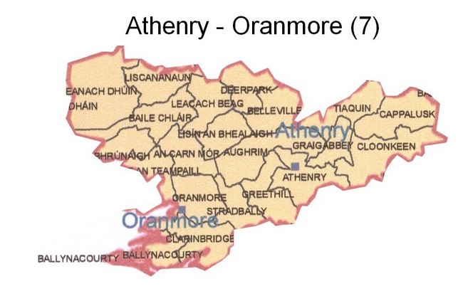
Athenry - Oranmore
An Carn Mór, Athenry, Aughrim, Baile an Teampaill, Baile Chláir, Ballynacourty, Belleville, Cappalusk, Ceathrú an Bhrúnaigh, Clarinbridge, Cloonkeen, Deerpark, Eanach Dhúin, Graigabbey, Greethill, Leacach Beag, Liscananaun, Lisín an Bhealaigh, Oranmore, Stradbally and Tiaquin.
|
|
| |
|
|
| |
 |
|
| |
|
|
| |
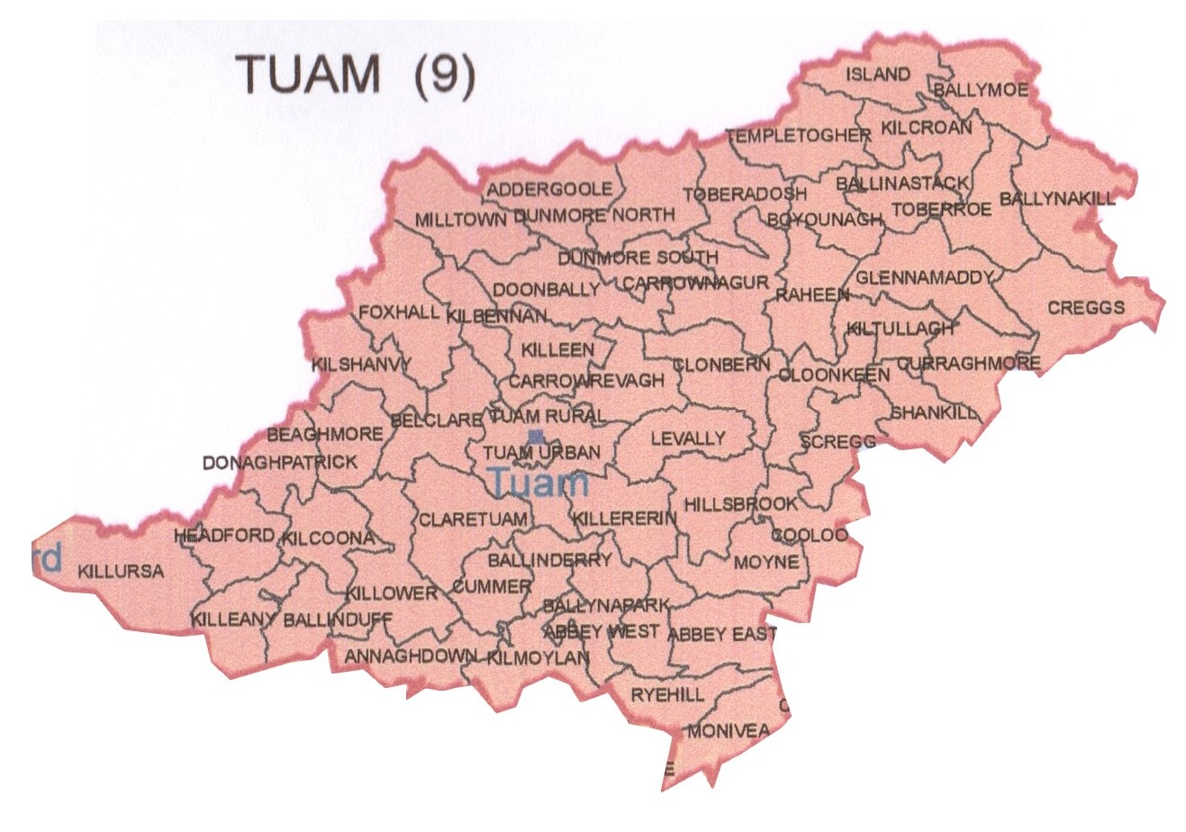
Tuam
Abbey East, Abbey West, Addergoole, Annaghdown, Ballinastack, Ballinderry, Ballinduff, Ballymoe, Ballynakill, Ballynapark, Beaghmore, Belclare, Boyounagh, Carrownagur, Carrowrevagh, Claretuam, Clonbern, Cloonkeen, Cooloo, Creggs, Cummer, Curraghmore, Donaghpatrick, Doonbally, Dunmore North, Dunmore South, Foxhall, Glennamaddy, Headford, Hillsbrook, Island, Kilbennan, Kilcoona, Kilcroan, Killeany, Killeen, Killererin, Killower, Killursa, Kilmoylan, Kilshanvy, Kiltullagh, Levally, Milltown, Monivea, Moyne, Raheen, Ryehill, Scregg, Shankill, Templetogher, Toberadosh, Toberroe, Tuam Rural and Tuam Urban. |
|
| |
|
|
| |
 |
|
| |
|
|
| |
Galway County Map |
|
| |
|
|
| |
 |
|
| |
|
|
| |
|
|
| |
|
|